


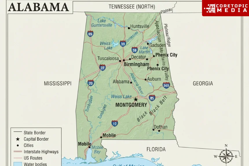
A map of Alabama shows a southeastern U.S. state stretching from the Appalachian foothills in the north to Mobile Bay and the Gulf of Mexico in the south. Alabama borders Tennessee, Georgia, Florida, and Mississippi, while Montgomery serves as the state capital.
Different maps reveal different parts of the state. A road map highlights Interstate 65 and other major highways, a county map divides Alabama into 67 counties, and a physical map shows mountains, river systems, plains, lakes, and the Gulf Coast.
For current driving information, the Alabama Department of Transportation offers official 2025–2026 highway maps as well as county and regional maps.
Quick guide to a map of Alabama
| Map feature | What it shows |
|---|---|
| State capital | Montgomery |
| Largest city by 2025 Census estimate | Huntsville |
| Other major cities | Birmingham, Mobile, Montgomery |
| Number of counties | 67 |
| Northern border | Tennessee |
| Eastern border | Georgia |
| Southern neighbors | Florida and Gulf of Mexico |
| Western border | Mississippi |
| Highest point | Cheaha Mountain, 2,407 feet |
| Major north-south interstate | I-65 |
| Major coastal interstate | I-10 |
| Major rivers | Tennessee, Alabama, Coosa, Tallapoosa, Tombigbee, Black Warrior |
| Gulf Coast counties | Mobile and Baldwin |
Alabama had an estimated population of 5,193,088 in July 2025, while the Census Bureau records 50,647.13 square miles of land area.
Where is Alabama on the U.S. map?
Alabama sits in the Southeastern United States.
On a national map, look east of Mississippi, west of Georgia, and south of Tennessee. Florida touches the southeastern portion of the state, while Alabama reaches the Gulf of Mexico through its southern coastline.
That position gives Alabama a long north-south shape.
The Alabama Department of Archives and History describes the state as roughly 330 miles long and 190 miles wide at its most distant points.
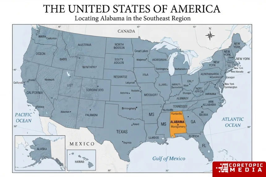
Its neighboring areas are easy to understand on a locator map:
| Direction | Neighbor |
|---|---|
| North | Tennessee |
| East | Georgia |
| Southeast | Florida |
| South | Gulf of Mexico |
| West | Mississippi |
Because Alabama reaches from Appalachian terrain to the Gulf Coast, a state map covers more geographic variety than its outline might initially suggest.
Map of Alabama cities
A city map of Alabama usually emphasizes Huntsville, Birmingham, Mobile, and Montgomery, followed by regional centers such as Tuscaloosa, Auburn, Dothan, Decatur, Florence, Gadsden, and Anniston.
Alabama Tourism currently highlights Huntsville, Birmingham, Mobile, and Montgomery as its four major cities.
Huntsville
Huntsville lies in northern Alabama, relatively close to the Tennessee state line.
The Census Bureau estimated its population at 233,627 in July 2025, making it Alabama’s largest city by that estimate series.
On a state map, Huntsville anchors the northern urban region.
Birmingham
Birmingham sits in north-central Alabama and remains one of the state’s most important metropolitan, transportation, business, and cultural centers.
The Census Bureau estimated Birmingham’s 2025 city population at 195,893.
The city’s location also makes it an important highway crossroads, particularly where major interstate corridors converge.
Montgomery
Montgomery occupies south-central Alabama and serves as the state capital.
The Alabama Historical Commission notes that state lawmakers selected Montgomery as the permanent capital in 1846 after Alabama had previously used other capital locations.
The Census Bureau estimated Montgomery’s population at 195,300 in 2025.
Mobile
Mobile lies in southwestern Alabama near Mobile Bay and the Gulf Coast.
Its location makes the city particularly prominent on transportation and coastal maps. The Census Bureau estimated Mobile’s population at 200,824 in 2025.
Travel maps often show Mobile alongside nearby Gulf Coast destinations such as Dauphin Island, Gulf Shores, Orange Beach, Fairhope, and Foley.
Alabama county map
An Alabama county map divides the state into 67 counties.
Both the Alabama Secretary of State and the Association of County Commissions of Alabama recognize the current 67-county structure.
Washington County is the oldest current county, dating to 1800, while Houston County became the newest in 1903.
The 67 counties are:
Autauga, Baldwin, Barbour, Bibb, Blount, Bullock, Butler, Calhoun, Chambers, Cherokee, Chilton, Choctaw, Clarke, Clay, Cleburne, Coffee, Colbert, Conecuh, Coosa, Covington, Crenshaw, Cullman, Dale, Dallas, DeKalb, Elmore, Escambia, Etowah, Fayette, Franklin, Geneva, Greene, Hale, Henry, Houston, Jackson, Jefferson, Lamar, Lauderdale, Lawrence, Lee, Limestone, Lowndes, Macon, Madison, Marengo, Marion, Marshall, Mobile, Monroe, Montgomery, Morgan, Perry, Pickens, Pike, Randolph, Russell, St. Clair, Shelby, Sumter, Talladega, Tallapoosa, Tuscaloosa, Walker, Washington, Wilcox, and Winston.
County maps are particularly useful when researching local government, property, elections, demographics, county seats, or rural travel.
The Alabama Department of Transportation also maintains county map resources, including GIS layers and detailed general highway maps.
Alabama road map and major highways
A road map of Alabama shows a network of interstates, U.S. highways, state routes, and county roads connecting cities from the Tennessee Valley to the Gulf Coast.
For the most authoritative statewide road reference, ALDOT currently provides highway maps labeled 2025–2026.
Major interstate corridors include:
Interstate 65
I-65 forms Alabama’s main north-south interstate spine.
It enters the state from Tennessee, crosses north and central Alabama, passes through the Birmingham and Montgomery corridors, and continues south toward Mobile.
For statewide road-trip planning, I-65 is one of the most important routes to locate first.
Interstate 10
I-10 crosses the extreme southern part of Alabama.
It connects the Mobile area with Mississippi to the west and Florida to the east, making it an essential Gulf Coast route.
Interstate 20
I-20 crosses Alabama from west to east and passes through the Birmingham region before continuing toward Georgia.
Interstate 59
I-59 runs through northeastern and central parts of the state and overlaps I-20 in the Birmingham area.
Interstate 85
I-85 begins in Montgomery and travels northeast through east-central Alabama toward Georgia.
It provides an important connection for the Auburn-Opelika region.
Interstate 22
I-22 extends northwest from Birmingham toward Mississippi and the Memphis regional corridor.
A detailed Alabama highway map also shows major U.S. routes and state highways that serve areas away from the interstate network.
Physical map of Alabama
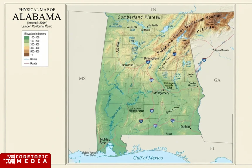
A physical map focuses on terrain rather than county or city boundaries.
Alabama’s landscape rises from low coastal areas in the south to foothills, ridges, valleys, plateaus, and mountains in the north and northeast.
The official Alabama Tourism Department describes northern Alabama as part of the southern Appalachian landscape, while the coast features beaches and Gulf waters.
Broadly, a physical map reveals several contrasting zones:
Northern Alabama: Appalachian foothills, Tennessee Valley, plateaus and ridges
Central Alabama: rolling uplands, valleys and river systems
Southern Alabama: broad Coastal Plain
Extreme south: Mobile Bay, wetlands, barrier islands and Gulf Coast
This geographic transition explains why a terrain map looks very different from a simple political outline.
Where is the highest point in Alabama?
Cheaha Mountain is Alabama’s highest point.
The U.S. Geological Survey lists Cheaha Mountain in Cleburne County at 2,407 feet above sea level. The state’s lowest point lies at sea level along the Gulf of Mexico.
Cheaha sits in eastern Alabama within the southern Appalachian region.
Therefore, an elevation map generally shows higher terrain concentrated toward northeastern Alabama, while elevation decreases toward the southern Coastal Plain and Gulf Coast.
Alabama rivers map
Rivers form an important part of Alabama’s geography.
Major river systems include:
- Tennessee River
- Coosa River
- Tallapoosa River
- Alabama River
- Tombigbee River
- Black Warrior River
- Cahaba River
- Chattahoochee River
- Mobile River
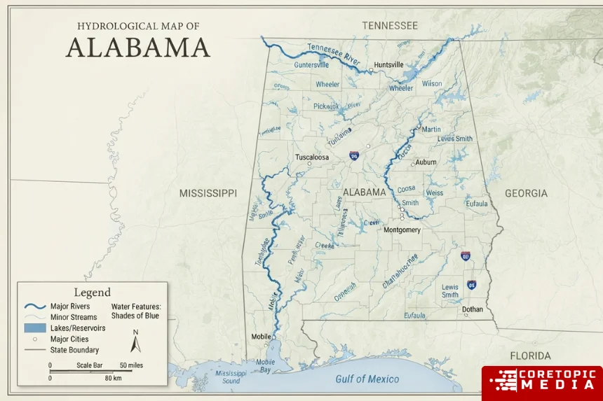
The Tennessee River crosses northern Alabama, while the Chattahoochee forms part of the eastern boundary with Georgia.
Farther south, the Alabama-Tombigbee system ultimately drains toward Mobile and the Gulf.
The University of Alabama’s cartographic resources, published through the Encyclopedia of Alabama, include maps showing river systems and drainage basins across the state.
Consequently, a river map can be useful for studying watersheds, transportation history, ecology, reservoirs, floodplains, and settlement.
Map of Alabama lakes
Many prominent Alabama lakes are reservoirs associated with major river systems.
Commonly mapped lakes include:
- Lake Guntersville
- Wheeler Lake
- Lake Martin
- Lewis Smith Lake
- Lake Eufaula
- Pickwick Lake
Lake Guntersville and Wheeler Lake lie along the Tennessee River system in northern Alabama.
Lake Martin lies on the Tallapoosa River, while Lake Eufaula sits along the Chattahoochee near the Georgia border.
Outdoor and travel maps often mark these lakes because they support fishing, boating, parks, recreation, and tourism.
Alabama Gulf Coast map
Alabama has a relatively small Gulf coastline compared with neighboring Florida, but the coast plays an outsized role in travel and geography.
The primary coastal counties are Mobile County and Baldwin County. USGS describes those two counties as coastal Alabama and places them within the East Gulf Coastal Plain.
Key coastal locations include:
Mobile: major city near Mobile Bay
Dauphin Island: barrier island south of Mobile
Gulf Shores: Gulf-facing beach community
Orange Beach: coastal resort city
Fairhope: eastern shore of Mobile Bay
Foley: inland gateway to the beach region
Fort Morgan: western end of the Baldwin County coastal peninsula
Alabama Tourism groups these destinations within its Beaches and Gulf Coast region.
Therefore, travelers planning a beach trip should use a more detailed Gulf Coast map rather than relying only on a statewide map.
North, central and south Alabama on a map
For travel purposes, Alabama can be understood as several broad regions.
The state tourism department currently organizes destinations into North, Central, South, and Beaches/Gulf Coast areas.
North Alabama
North Alabama includes Huntsville, Decatur, Florence, Muscle Shoals, Lake Guntersville, Lookout Mountain, and the Tennessee Valley.
It also includes much of Alabama’s highest and most rugged terrain.
Central Alabama
Central Alabama includes Birmingham, Tuscaloosa, Talladega, parts of the Piedmont, and areas surrounding Lake Martin.
This region forms an important transportation and population corridor.
South Alabama
South Alabama includes Montgomery, Selma, Dothan, Tuskegee, Monroeville, Eufaula, and the Wiregrass.
The landscape becomes progressively flatter toward the coast.
Gulf Coast
Mobile, Baldwin County, Gulf Shores, Orange Beach, Dauphin Island, and Mobile Bay form the state’s principal coastal area.
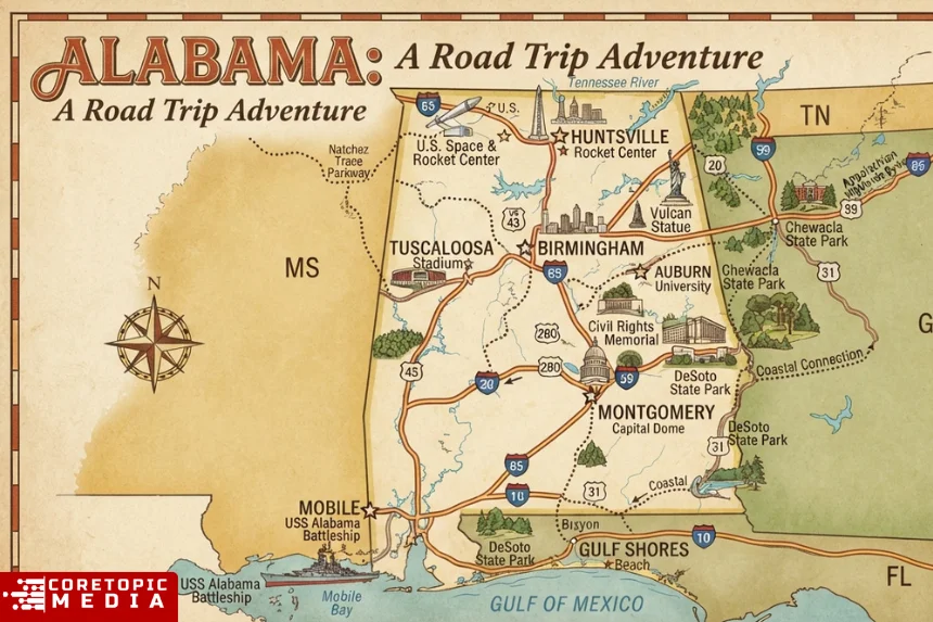
What is the best Alabama map for a road trip?
Use the official ALDOT highway map when road routing and statewide transportation matter most.
ALDOT’s map page currently provides 2025–2026 highway maps as well as county, district, political, railway, and other transportation maps.
For attractions and vacation planning, the Alabama Tourism interactive map adds destinations and regional travel context.
A good trip-planning approach combines:
Highway map: interstate and route planning
Interactive map: attractions and destinations
City map: local streets and neighborhoods
Physical map: mountains, lakes and outdoor areas
For live navigation, however, use a current GPS or navigation service because static highway maps cannot reflect every closure, construction zone, or traffic condition.
Where can you find an official printable map of Alabama?
The Alabama Department of Transportation is the strongest source for an official state highway map.
Its current map library includes:
- 2025–2026 highway maps
- County maps
- District and regional maps
- Political maps
- General milepost maps
- Railway maps
ALDOT also offers information for requesting physical state maps.
The Alabama Tourism Department provides another option for visitors. Its travel-guide pages allow U.S. residents to request an official travel guide and highway map.
For demographic and administrative reference maps, the U.S. Census Bureau also publishes downloadable geographic maps.
Historical maps of Alabama
Historical maps can show how Alabama changed over time.
The Alabama Department of Archives and History maintains a digital map collection containing early state maps, transportation maps, county maps, and other cartographic material.
For example, its digitized 1832 Map of Alabama shows county boundaries and early railroad routes.
Historical maps can help researchers study:
- Changing county boundaries
- Early roads and railroads
- Settlement patterns
- Town development
- River transportation
- Political boundaries
- Land use
However, historical maps should not guide modern travel because road alignments, place names, borders, and infrastructure may have changed considerably.
How to choose the right map of Alabama
Choose your map based on what you need to locate.
| Goal | Best map type |
|---|---|
| Find cities | City/state reference map |
| Find all 67 counties | County map |
| Plan a road trip | Current highway map |
| Study mountains | Physical or topographic map |
| Locate rivers | Hydrology map |
| Visit beaches | Gulf Coast travel map |
| Research population | Census map |
| Study elections | Political district map |
| Explore attractions | Interactive tourism map |
| Study Alabama history | Historical map |
No single map needs to show everything.
In fact, adding every highway, county, stream, city, landmark, and elevation contour to one statewide graphic usually makes it harder to read.
Frequently asked questions about a map of Alabama
1. Where is Alabama on the map?
Alabama lies in the southeastern United States. Tennessee borders it to the north, Georgia to the east, Mississippi to the west, and Florida and the Gulf of Mexico to the south.
2. What is the capital of Alabama?
Montgomery is Alabama’s capital. The state legislature selected it as the permanent capital in 1846.
3. What is the largest city in Alabama?
Huntsville is the largest Alabama city by the Census Bureau’s July 2025 population estimates, with 233,627 residents.
4. How many counties are on an Alabama map?
Alabama has 67 counties. Washington County is the oldest current county, while Houston County is the newest.
5. What states border Alabama?
Alabama shares land boundaries with Tennessee, Georgia, Florida, and Mississippi. In addition, the southern part of the state reaches the Gulf of Mexico.
6. What are Alabama’s major interstate highways?
Major routes include I-10, I-20, I-22, I-59, I-65, and I-85. A current ALDOT highway map provides the best statewide reference for Alabama’s official road network.
7. Where is the Gulf Coast in Alabama?
The coast lies at Alabama’s southern end, primarily in Mobile and Baldwin counties. Major coastal destinations include Mobile, Gulf Shores, Orange Beach, Dauphin Island, and Fairhope.
8. What is Alabama’s highest point?
Cheaha Mountain in Cleburne County is the state’s highest point at 2,407 feet, according to USGS.
9. Where can I get a printable Alabama road map?
ALDOT publishes current highway and county map resources and provides information for requesting state maps. Alabama Tourism also offers an official highway map through its travel-guide program.
10. What type of Alabama map is best for school?
A political map works well for cities, county boundaries, the capital, and neighboring states. However, use a physical map when the assignment focuses on rivers, mountains, elevation, lakes, or geographic regions.
Conclusion
A map of Alabama can show far more than the state’s familiar outline. City maps locate Huntsville, Birmingham, Mobile, Montgomery, and other communities; county maps divide the state into 67 counties; road maps reveal major transportation corridors; and physical maps show the transition from Appalachian terrain to the Gulf Coast.
For travel, the Alabama Department of Transportation’s current highway maps provide an authoritative starting point. Meanwhile, Alabama Tourism offers interactive destination maps, the Census Bureau provides demographic geography, and historical collections help researchers see how the state changed over time.
Ultimately, the best Alabama map depends on the question. Use a road map to drive, a county map for boundaries, a physical map for geography, and a coastal map when planning a trip to Mobile Bay or Alabama’s beaches.
Readers seeking a broad reference can also view Alabama on Wikipedia, while official government sources remain preferable for current highways, boundaries, and statistics.